Part Two
Point 7
Point 8
Point 9
Point 10
Part 3
Main Menu
The Constitution pub and Grays Inn Bridge. Note foundation stone in opposite wall. After here go on 500 yards to oblique bridge. The Landowner fought long legal battles with the canal over building this stretch.
Back
Next
Camley St. Bridge. Note remains of stop gates used in World War Two to limit risk of flooding of railway tunnels if the canal had been damaged by bombs. During bombing raids they were closed. In fact the canal was never breached during the war. Go on under two bridges to basin.
Back
Next
St. Pancras Basin and Lock. Basin built 1867 for railway ash disposal. Now home to Saint Pancras Cruising Club, established in 1958, and a new dry dock. Note the lock keepers cottage C1890, which also contained a steam pump. Behind the lock cottage is the water tower of St. Pancras Station. It once supplied water to railway locomotives and was moved to this site in 2001 to enable the station to be redeveloped. Guided tours from the museum to the top are provided occasionally. Go on to indentation in canal 200 yards below. You will cross the entrance to a former canal basin.
Back
Next
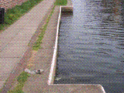
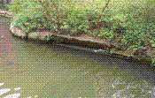
Horse ramp. A sloping indentation to enable horses that had fallen in canal to be led out. Often these were sited near railways in case the horses were frightened by trains and fell in. Left was Midland Railway stables and horse hospital.
Back
Next